Cool, wet August ends mixed summer
After a dry and warm start, summer 2015 is set to end on an average note with temperatures and rainfall close to normal for the season.
Despite a dry and sunny June and a brief heat-wave at the start of July, summer overall looks set to be cooler than average and cooler than either summer 2013 or 2014. It has also been rather wetter than average, however sunshine totals are expected to be near average.
In general the weather has been dominated by a westerly flow from the Atlantic, bringing often cool and rather wet conditions, especially in the north and west, with the south-east generally experiencing the best of any warm, dry, sunny spells.
Using provisional figures up to 26 August and then assuming average conditions for the final few days of the month, Met Office statistics show the UK mean temperature for this summer will be around 14 °C. This is 0.4 °C below the long term average (1981-2010).
Rainfall overall is slightly higher than average, with the UK so far having seen 271 mm of rain - which is 13 % above the long-term average. Rainfall from the final few days of August is likely to increase this number slightly further. However, across southern and eastern England this rain has often come from short, heavy downpours and these have been interspersed with some fine, dry days.
The Met Office's Chief Scientist Professor Dame Julia Slingo OBE FRS reflects on this summer's weather and what has influenced it.
Monthly Overview
As ever when looking over a whole season, the statistics mask some big variations between each month.
June had an unseasonably unsettled start with a low pressure system bringing strong gusts of wind and heavy rain for the first couple of days. After this, the month was generally more settled, especially over southern areas with England, Wales and Northern Ireland drier and sunnier than average. However, it was rather cool, wet and dull across the north and west of Scotland.
July began with a record-breaking 'heat-wave' on the 1st of the month with a maximum temperature of 36.7 °C recorded at Heathrow, a new July record and the UK's highest recorded temperature since August 2003. However, this was soon swept away by a cold front. The remainder of the month was characterized by a westerly winds bringing often more unsettled, cooler and wetter conditions from the Atlantic, particularly in the north - there were some notably cool nights in the second half of the month and some significant thunderstorms bringing torrential downpours, however, there were drier and more settled conditions in the south-east.
The weather so far in August has continued to be fairly mixed, with some fine days interspersed with more unsettled periods of weather. Temperatures overall have been near average, although rather cool in the south-west. It has been especially wet and dull along the south coast of England. However, there have been some warmish days in parts of eastern England with temperatures up to around 25 °C.
Looking specifically at the early August figures, released today, the UK mean temperature up to the 26th of the month is 14.8 °C which is 0.1 °C below the long-term average, with the coolest conditions relative to average in south-west England.
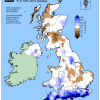
In terms of rainfall, overall August has only been slightly wetter than average, however, due to heavy and thundery downpours in southern parts, some areas have seen notably high totals with Cornwall and much of the south coast seeing more than double their average rainfall so far this month.
August sunshine totals have been near average across many areas, but it has been a dull month for much of southern England, especially the south-east.


